|
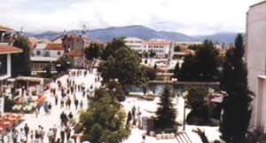  The town of Struga is located on the shore of Lake Ohrid at the southernmost edge of the Struga Valley. At an altitude of 695m above sea level, Struga is 171km away from Skopje via Kicevo and 184km via Debar. The town is surrounded by Mt. Jablanica in the west, Mt. Mokra in the east, Mt. Karaorman in the north, and Lake Ohrid in the south. The city is divided by the river Crn Drim (Black Drim), which flows out of Lake Ohrid straight through the heart of Struga. Located on both a lake and a river, Struga has a unique charm and beauty. The town of Struga is located on the shore of Lake Ohrid at the southernmost edge of the Struga Valley. At an altitude of 695m above sea level, Struga is 171km away from Skopje via Kicevo and 184km via Debar. The town is surrounded by Mt. Jablanica in the west, Mt. Mokra in the east, Mt. Karaorman in the north, and Lake Ohrid in the south. The city is divided by the river Crn Drim (Black Drim), which flows out of Lake Ohrid straight through the heart of Struga. Located on both a lake and a river, Struga has a unique charm and beauty.
Tourism is seen as a priority for regional development, but it does not lag behind in the development of textile industry, agriculture, and forestry, either.
The town is characterized by its old and authentic architecture, typical of the entire region. Struga's history begins with the Neolithic Age, from which there are many famous archeological sites.
In the 4th century Struga became part of the Byzantine Empire. The first missionary to arrive in this region was the Bishop from Antiochia, Erazmus. This is when the first churches in Struga and its surroundings were built.
In the 6th and the 7th centuries, Slavs came and settled in these regions.
In the 11th century, Byzantine travelogue writer Anna Komnina visited Struga and referred to the town as “a town of 1,000 bridges," because the river bed was dug through and many bridges were built during the rule of Macedonian Emperor Samuil (10th-11th century).
 |
Monuments |
|
 |
Halveti Tekke |
| |
St. Georgi Church |
| |
St. Bogorodica Church | | |
|
|
Events |
|
| |
Struga Poetry Evenings |
| |
Vevcani Carnival | | | |